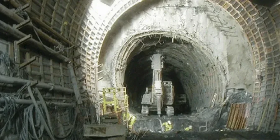
The mud rotary drill rig sits on the high plains, pulling Shelby tubes from 40 feet down while the crew logs every change in material. That is where our work starts. In Laramie, at 7,165 feet of elevation, the subsurface tells a complex story: Quaternary alluvium overlying the Casper Formation, interbedded with lenses of saturated silt and organics left by old oxbows of the Laramie River. Soft ground tunneling here means dealing with groundwater perched above bedrock and fine-grained soils that lose strength fast when disturbed. We run the site investigation, collect undisturbed samples, and bring them to our lab for a full geotechnical analysis for soft soil tunnels. The lab tests make the difference between a tunnel boring machine getting stuck and a drive that stays on schedule. Before mobilizing the drill crew, we often coordinate with a test pit program to map shallow stratification and identify buried utilities that could complicate the alignment.
In Laramie Basin soft ground, the difference between a successful tunnel drive and a collapse often comes down to knowing the undrained shear strength of that one silt seam nobody sampled.
Local geotechnical context
A contractor was advancing a utility tunnel near Spring Creek when the crown started raveling. Water was trickling in, and the siltstone face was sloughing in small blocks. The original investigation had logged the material as stiff clay, but nobody had measured pore pressure in the silt seams. When we re-drilled the alignment, the piezometers told a different story: artesian conditions in a sand lens just above the tunnel crown, not accounted for in the support design. In Laramie, perched groundwater in the alluvial sequence creates exactly this kind of risk. Soft soil tunnels here need a geotechnical analysis that goes beyond classification and gives the contractor a realistic ground model, including stand-up time estimates and face stability calculations. Tunnel designers working in the basin also need to consider the interaction between soft ground behavior and nearby deep excavations, where dewatering on one project can trigger settlement on another.
Questions and answers
What soil types in Laramie are considered 'soft ground' for tunneling?
In the Laramie Basin, soft ground typically means the Quaternary alluvium: silty clays (CL), low-plasticity silts (ML), and occasional high-plasticity clays (CH) found in old river channel deposits. These soils have undrained shear strengths below 1.5 ksf and are prone to squeezing or raveling when exposed at the tunnel face. The Casper Formation sandstone and limestone beneath the alluvium are competent rock, but the transition zone between soil and weathered bedrock is often the most problematic section for tunnel stability.
How much does a geotechnical analysis for a soft soil tunnel in Laramie cost?
A full geotechnical investigation for a soft soil tunnel in Laramie, including drilling, sampling, lab testing, and the interpretive report, ranges from US$4,490 for a small-diameter short alignment to US$17,590 for a comprehensive program with multiple boreholes, piezometer installation, and advanced triaxial testing. The final cost depends on the tunnel length, depth, access constraints, and how many lab tests are required to characterize the ground variability.
What lab tests are essential for soft ground tunnel design?
At minimum, you need unconsolidated-undrained (UU) triaxial tests to get undrained shear strength for face stability calculations, consolidation tests for settlement and time-rate estimates, and index tests (grain size, Atterberg limits) for soil classification per ASTM D2487. If the tunnel alignment crosses multiple strata, we also recommend consolidated-undrained (CU) triaxial tests with pore pressure measurement to get effective stress parameters for long-term ground behavior.
How long does the investigation take before a report is delivered?
Field drilling and sampling for a typical Laramie tunnel investigation takes 3 to 7 working days depending on borehole depth and number of locations. Lab testing adds 2 to 4 weeks, with consolidation tests requiring the longest lead time due to incremental loading. The final interpretive report is delivered within 4 to 6 weeks after field work is completed, though preliminary parameters can be provided earlier for design teams working on tight schedules.
Do you install piezometers for groundwater monitoring during tunnel construction?
Yes. We install standpipe piezometers or vibrating wire piezometers in dedicated monitoring wells along the tunnel alignment. In the Laramie Basin, perched groundwater in the alluvium is a key factor for tunnel face stability, and seasonal fluctuations can change conditions significantly between investigation and construction. We recommend continuous monitoring from the investigation phase through tunnel excavation to track any changes in pore pressure.