At 7,165 feet above sea level, Laramie's construction season is short and the ground doesn't forgive guesswork. Winter frost can reach four feet deep here, and the transition from decomposed granite to alluvial silts happens fast across the Laramie Basin. An exploratory test pit puts you right at the section face—you see the stratigraphy, measure layer thicknesses with a tape, and grab undisturbed samples that a drill rig would shear. For crews working on the east side near the Laramie River or up in the Sherman Granite foothills, we dig these pits with a tracked excavator that handles the rocky overburden. Once the cut is open, our geologist logs the profile per ASTM D2487 while the atterberg limits lab work confirms the classification of any fine-grained seams that the eye can't resolve. We cross-check pit observations with spt-drilling when the project extends deeper than the 12 to 14 feet we can reach with the bucket, giving you a continuous data set from surface to bearing depth.
A test pit doesn't just log layers—it shows you the joints, the moisture, and the cobbles that a split spoon never retrieves.
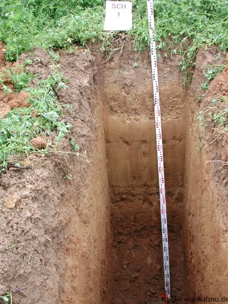
Local geotechnical context
We opened a pit on a slope off Snowy Range Road for a retaining wall project, and at six feet down we hit a wet lens of silty sand perched on a granite bedrock saddle. The hillside looked dry from the surface, but that trapped water would've turned the backfill into a hydraulic nightmare once the wall was poured. Without the exploratory test pit, the contractor would've placed reinforcement in a zone that was going to saturate every spring thaw. Laramie's decomposed granite weathers into a micaceous sand that stands up well in a cut until it doesn't—a little seepage and the face slumps fast. When we open these pits in residential zones near LaPrele Park, we also check for old buried debris from the 1950s subdivisions that predate Albany County's grading codes. Finding a pocket of wood waste or ash at the bottom changes your foundation recommendation from a shallow spread footing to an over-excavation and engineered fill lift, and that call has to happen before the concrete truck arrives.
Questions and answers
What does an exploratory test pit cost in the Laramie area?
For a standard pit up to 12 feet deep with logging, sampling, and backfill, the cost in Albany County typically falls between US$460 and US$720 per pit. The final number depends on access constraints, the number of pits, and whether you need lab testing on the recovered samples. We quote the excavation and the lab work as separate line items so you see exactly where the budget goes.
How do you handle backfill and surface restoration after the pit is done?
We backfill in controlled lifts, compacting each one with the excavator bucket or a plate compactor if space allows. The surface is graded to match the surrounding grade, and we reseed disturbed areas with a native grass mix suited to Laramie's high-desert conditions—usually a blend of blue grama and western wheatgrass.
Can you open a test pit in winter when the ground is frozen solid?
Yes, but it takes longer. We use a hydraulic breaker attachment on the excavator to cut through the frozen crust, which can be three to four feet thick in Laramie by January. Once we're past the frost line, digging speed returns to normal. We schedule winter pits with a wider weather window because a heavy snow can delay access for a day or two.
How deep can you go with a test pit versus an SPT boring?
With our standard excavator, we max out around 12 to 14 feet in Laramie's typical ground. If your bearing layer is deeper than that—say you're founding on the Casper Formation sandstone at 20-plus feet—we'll combine a few shallow test pits for the fill and alluvial layers with an SPT drilling program that reaches the deeper strata. You get visual data near the surface and penetration resistance at depth, all in one report.